
Key Facts
- Warning Period: to
- Severity: Yellow (medium impact, high likelihood)
- Primary Risks: Flash flooding, frequent lightning, hail damage
- Affected Regions: All of Wales, Midlands, Southeast England, and parts of Northern England
- Rainfall: 30–50mm possible within 1–3 hours in localized areas
Insights
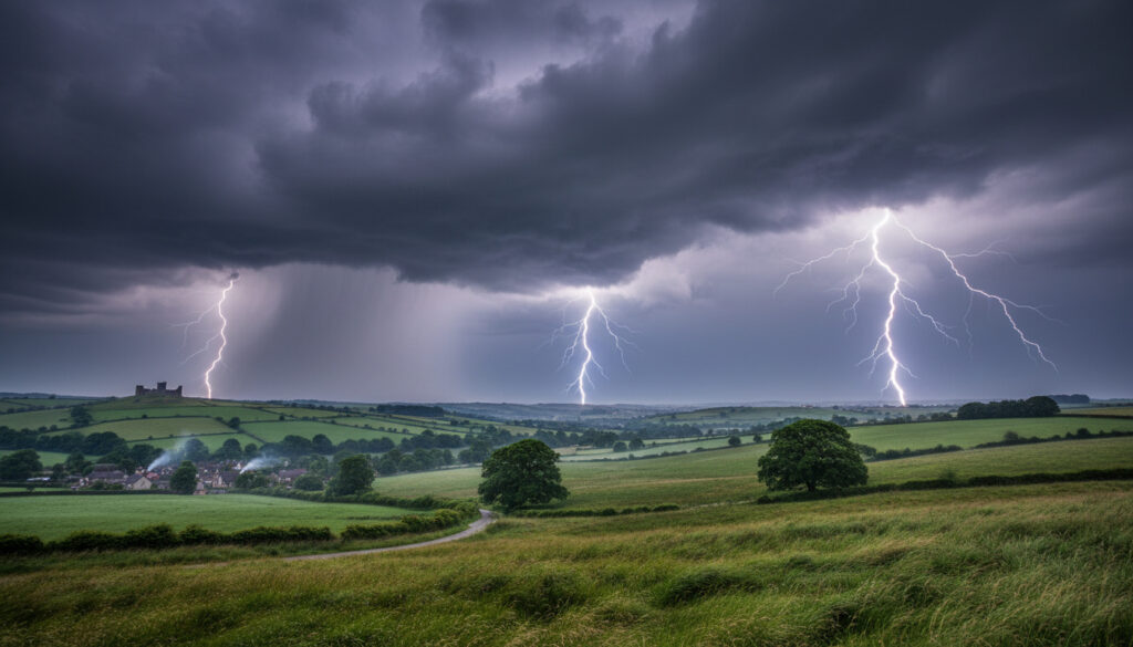
The current atmospheric setup features a plume of subtropical moisture streaming northward from the Bay of Biscay, creating an unstable thermodynamic environment ripe for convective development. When this warm air meets the cooler, denser air mass stationed over the North Sea, the resulting atmospheric volatility produces the cumulonimbus towers responsible for the predicted electrical activity. BBC Weather analysts note that surface temperatures exceeding 24°C across the southeast will provide sufficient energy to sustain storm cells well into the evening hours. Historical weather data indicates similar patterns in late spring typically generate brief but intense precipitation events rather than prolonged rainfall.
Affected Areas
| Region | Warning Start | Warning End | Primary Risk |
|---|---|---|---|
| Southeast England | Lightning, flash flooding | ||
| Midlands | Large hail, gusty winds | ||
| Wales | Persistent heavy rain | ||
| Southwest England | Thunder, surface water |
Specific Hazards
Specific hazards vary by region, with the Midlands facing the highest probability of hailstones exceeding 2cm in diameter, capable of damaging vehicles and greenhouse structures. Urban drainage systems in London and Birmingham may struggle with intensity rates of 30mm per hour, leading to rapid accumulation on roads and rail lines. The Environment Agency has preemptively issued flood alerts for low-lying areas along the Thames Valley and Severn catchments, advising residents to secure loose outdoor items and avoid walking through floodwater. Lightning frequency could reach 10–15 strikes per square kilometer in the most active cells, posing risks to infrastructure and open-air events.
Expected Timeline
Thursday afternoon marks the initial phase as storm cells develop over the Welsh Marches and track eastward toward the West Midlands. Peak intensity is expected between and when a secondary wave of moisture injection coincides with peak daytime heating. The Manchester City Council has activated emergency protocols for the Friday evening commute, anticipating disruption to tram networks and major arterial routes. By Saturday afternoon, the system gradually shifts northward into Yorkshire and the Northeast, though residual instability may trigger isolated showers through Sunday morning.
Understanding the Warning
Yellow warnings represent the middle tier of the Met Office’s three-tier system, indicating that severe weather is likely and may cause disruption to daily routines. Unlike amber or red warnings, yellow status suggests the majority of the population will experience manageable conditions, but localized impacts could prove significant. Emergency preparedness guidelines recommend keeping mobile devices charged and maintaining a basic kit of torches and bottled water during active warning periods. It is important to distinguish between the warning—covering broad geographic areas—and individual weather alerts, which target specific immediate threats.
Meteorological Context
This event aligns with increasingly volatile spring weather patterns observed over the past decade, where rapid temperature fluctuations create favorable conditions for convective storms. Meteorologists suggest that while individual weather events cannot be attributed directly to climate trends, the warming atmosphere holds greater moisture capacity, potentially increasing the intensity of short-duration rainfall. Recent climate research indicates that southern England has experienced a 15% increase in thunderstorm frequency during May and June over the past thirty years. The current synoptic chart resembles the setup from June 2023, when similar warnings resulted in significant flooding across Devon and Cornwall.
Official Statements
“The developing situation shows classic signs of high-based thunderstorms with considerable vertical development. We anticipate these storms will produce frequent lightning and locally intense rainfall that may overwhelm drainage systems in urban centers.”
— Met Office spokesperson
The national weather service emphasizes that while the warnings cover broad regions, impacts will remain highly localized, with some areas experiencing minimal disruption while adjacent neighborhoods face significant flooding. Transport for London advised passengers to check journey planners before Friday evening travel, noting that surface water creates particular hazards for bus operations.
Summary
The thunderstorm warnings affecting England and Wales through Saturday evening require residents to remain vigilant for rapidly changing conditions, particularly during afternoon and evening periods when storm activity peaks. While the yellow status indicates widespread severe disruption is unlikely, the potential for flash flooding and lightning damage necessitates sensible precautions, including securing outdoor furniture and avoiding unnecessary travel during intense rainfall. Monitoring local forecasts and heeding specific flood alerts will prove essential as the situation evolves.
Frequently Asked Questions
What is the difference between a weather watch and a warning?
A watch indicates conditions are favorable for severe weather, while a warning means severe weather is occurring or imminent.
How much rain is expected?
Most locations will see 10–20mm, but localized areas could receive 50mm within one to three hours.
Should I cancel outdoor events?
Consider having contingency plans for Friday afternoon and evening, though storms will be hit-and-miss rather than continuous.
Are schools likely to close?
Unlikely unless specific flooding affects individual buildings; yellow warnings typically do not trigger widespread closures.
How can I receive live updates?
Follow the Met Office app and local news sources for real-time radar updates and localized alerts.
Oliver Hayes is a staff writer for CivicInsight.uk, reporting on news, local government and public services. His work is reviewed by the editorial desk and checked against our sourcing and fact-checking standards before publication.